The pedestrian experience in many Walk Friendly Communities is enhanced by comprehensive and well-planned wayfinding systems. Wayfinding can increase pedestrian circulation and reinforce sense of place. Signs, maps, and tours indicate a community’s support for walking culture and are a good way for municipalities to encourage and facilitate walking for many different purposes, including recreational, utilitarian, and fitness. Positive experiences navigating a city may lead to longer tourist stays and inspire deeper exploration of what a community has to offer.
Charlotte, NC’s Wayfinding and parking Guidance System combines a dynamic parking system with a downtown pedestrian map and wayfinding system to encourage a “park once” mindset. Funded by the Congestion Mitigation and Air Quality Improvement Program, Charlotte’s urban signage leads motorists to available parking and allows them to further explore Charlotte’s city center on foot or use transit to easily access other parts of town, thus reducing greenhouse gases and emissions. Designers of Charlotte’s system focused on helping pedestrians create a ‘mental map’ of downtown by dividing the area into smaller, more defined districts, and highlighting the attractions within each district.
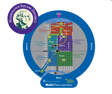
Philadelphia uses their extensive wayfinding system to point walkers towards transit as well as lead them to destinations accessible by foot, most often within a two to five block radius. Their system consists of over 650 signs and around 400 pole mounted “diskmaps,” (pictured) oriented in a “heads-up” position, which puts the direction the viewer is facing at the top of the map, plus over 100 “transit portal” signs that are integrated with the pedestrian wayfinding system. Six downtown districts are highlighted in the wayfinding system, and five of the six district icons were designed to reference William Penn’s 1682 plan for the city.
Eugene, OR is developing an innovative interactive downtown pedestrian wayfinding system which will ‘encourage visitors to discover the assets of the city’. The city’s planned high- tech kiosks will contain iBeacons, Wifi, interactive screens, charging stations and solar power. With the aid of a map-based smartphone app, pedestrians will find orientation maps, directional information, landmark history, events, and advertisements. The wayfinding system is being designed to complement Eugene’s distinctive artful downtown culture, and highlight the plentiful landmarks and vibrant urban atmosphere the town has to offer.
Communities that provide information about places to walk may enjoy higher rates of walking. Often referred to as the ‘unsung hero’ of city planning, wayfinding should not be overlooked as a means to improve your streets and communities.